படிமம்:Gulf of Thailand.svg
Jump to navigation
Jump to search

Gulf_of_Thailand.svg (SVG கோப்பு, பெயரளவில் 488 × 479 பிக்சல்கள், கோப்பு அளவு: 387 KB)
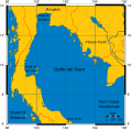
Mercator projection of Gulf of Thailand.
Public Domain map created by Online Map Creation:
http://www.aquarius.geomar.de/omc/omc_intro.html archive copy at the Wayback Machine
Modified by me (Feydey).
Other versions
-
 Italiano
 -
 Македонски
 -
 বাংলা
বাংলা


| This work has been released into the public domain by its author, Feydey. This applies worldwide. சில நாடுகளில் இது சாத்தியமில்லாது போகலாம். அவ்வாறாயின் : Feydey grants anyone the right to use this work for any purpose, without any conditions, unless such conditions are required by law.
|
derivative works
Derivative works of this file:
கோப்பின் வரலாறு
குறித்த நேரத்தில் இருந்த படிமத்தைப் பார்க்க அந்நேரத்தின் மீது சொடுக்கவும்.
| நாள்/நேரம் | நகம் அளவு சிறுபடம் | அளவுகள் | பயனர் | கருத்து | |
|---|---|---|---|---|---|
| தற்போதைய | 11:06, 16 சனவரி 2020 | | 488 × 479 (387 KB) | wikimediacommons>Paul 012 | The label "Andaman Sea" was in the area officially defined as the Strait of Malacca. |
கோப்பு பயன்பாடு
இப் படிமத்துக்கு இணைக்கப்பட்டுள்ள பக்கங்கள் எதுவும் இல்லை.