
படிமம்:Karta AngkorWat.PNG
இந்த முன்னோட்டத்தின் அளவு: 267 × 210 படப்புள்ளிகள் . மற்ற பிரிதிறன்: 700 × 550 படப்புள்ளிகள் .
மூலக்கோப்பு (700 × 550 படவணுக்கள், கோப்பின் அளவு: 21 KB, MIME வகை: image/png)

|
This map image could be re-created using vector graphics as an SVG file. This has several advantages; see Commons:Media for cleanup for more information. If an SVG form of this image is available, please upload it and afterwards replace this template with
{{vector version available|new image name}}.It is recommended to name the SVG file “Karta AngkorWat.svg”—then the template Vector version available (or Vva) does not need the new image name parameter. |
சுருக்கம்
| விளக்கம் |
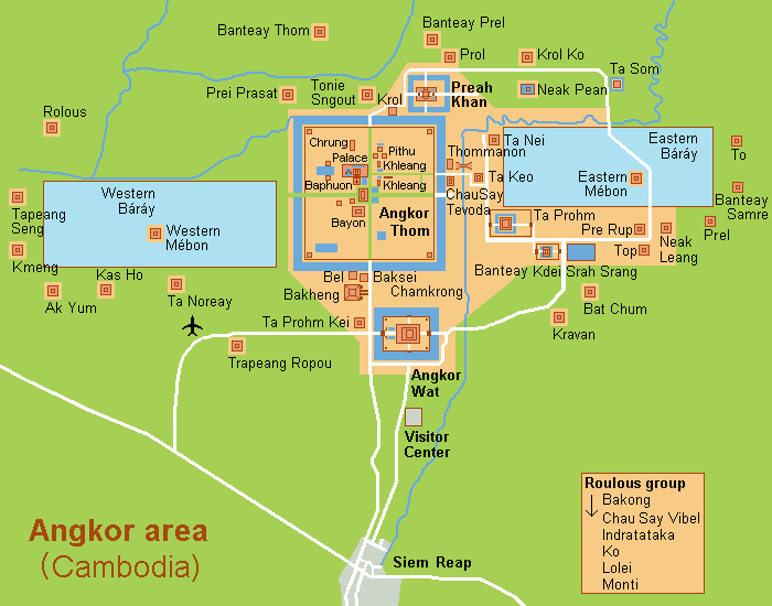
English: Map (rough) of Angkor Wat, Cambodja. |
| நாள் | |
| மூலம் | சொந்த முயற்சி , composed from various mapreferences |
| ஆசிரியர் | Hobe / Holger Behr |
அனுமதி
| I, the copyright holder of this work, release this work into the public domain. This applies worldwide. சில நாடுகளில் இது சாத்தியமில்லாது போகலாம். அவ்வாறாயின் : I grant anyone the right to use this work for any purpose, without any conditions, unless such conditions are required by law. |
கோப்பின் வரலாறு
குறித்த நேரத்தில் இருந்த படிமத்தைப் பார்க்க அந்நேரத்தின் மீது சொடுக்கவும்.
| நாள்/நேரம் | நகம் அளவு சிறுபடம் | அளவுகள் | பயனர் | கருத்து | |
|---|---|---|---|---|---|
| தற்போதைய | 10:08, 11 செப்டெம்பர் 2010 | | 700 × 550 (21 KB) | wikimediacommons>Hobe | extension |
கோப்பு பயன்பாடு
பின்வரும் பக்க இணைப்புகள் இப் படிமத்துக்கு இணைக்கபட்டுள்ளது(ளன):