படிமம்:LocationSapmi.png
Jump to navigation
Jump to search

இந்த முன்னோட்டத்தின் அளவு: 215 × 209 படப்புள்ளிகள் . மற்ற பிரிதிறன்: 811 × 789 படப்புள்ளிகள் .
மூலக்கோப்பு (811 × 789 படவணுக்கள், கோப்பின் அளவு: 45 KB, MIME வகை: image/png)

|
This linguistic map image could be re-created using vector graphics as an SVG file. This has several advantages; see Commons:Media for cleanup for more information. If an SVG form of this image is available, please upload it and afterwards replace this template with
{{vector version available|new image name}}.It is recommended to name the SVG file “LocationSapmi.svg”—then the template Vector version available (or Vva) does not need the new image name parameter. |
சுருக்கம்
| விளக்கம் |
Čeština: Mapa sámské domoviny v severní Evropě
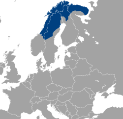
English: Location of Sápmi.
Dansk: Laplands omtrentlige udstrækning. |
| நாள் | 4 மே 2004 (original upload date) |
| மூலம் | Transferred from en.wikipedia to Commons. |
| ஆசிரியர் | Rogper at ஆங்கிலம் விக்கிப்பீடியா |
| ஒத்தக்கோப்பு | Derivative works of this file: LocationSapmi-2.png |
.png)
அனுமதி

|
GNU Free Documentation License விதிமுறைகளின் கீழ் இந்த ஆவணத்தை நகலெடுக்க, விநியோகிக்க மற்றும்/அல்லது மாற்றுவதற்கு அனுமதி வழங்கப்பட்டுள்ளது, Free Software Foundation;ஆல் வெளியிடப்பட்ட பதிப்பு 1.2 அல்லது அதற்குப் பிந்தைய பதிப்பு, மாற்றமில்லாத பிரிவுகள், முன் அட்டை உரைகள் மற்றும் பின் அட்டை உரைகள் இல்லாமல் வெளியிடப்பட்டது. GNU Free Documentation License என்ற தலைப்பில் உரிமத்தின் நகல் சேர்க்கப்பட்டுள்ளது. |
| இந்த கோப்பு Creative Commons Attribution-Share Alike 3.0 Unported உரிமத்தின் கீழ் உள்ளது. | ||
| ||
| This licensing tag was added to this file as part of the GFDL licensing update. |
கோப்பின் வரலாறு
குறித்த நேரத்தில் இருந்த படிமத்தைப் பார்க்க அந்நேரத்தின் மீது சொடுக்கவும்.
| நாள்/நேரம் | நகம் அளவு சிறுபடம் | அளவுகள் | பயனர் | கருத்து | |
|---|---|---|---|---|---|
| தற்போதைய | 15:05, 6 பெப்பிரவரி 2012 | | 811 × 789 (45 KB) | wikimediacommons>Fobos92 | . |
கோப்பு பயன்பாடு
இப் படிமத்துக்கு இணைக்கப்பட்டுள்ள பக்கங்கள் எதுவும் இல்லை.