படிமம்:Hausa language map.png
Jump to navigation
Jump to search
இந்த முன்னோட்டத்தின் அளவு: 165 × 209 படப்புள்ளிகள் . மற்ற பிரிதிறன்: 3,571 × 4,519 படப்புள்ளிகள் .
மூலக்கோப்பு (3,571 × 4,519 படவணுக்கள், கோப்பின் அளவு: 447 KB, MIME வகை: image/png)
சுருக்கம்
| விளக்கம் |
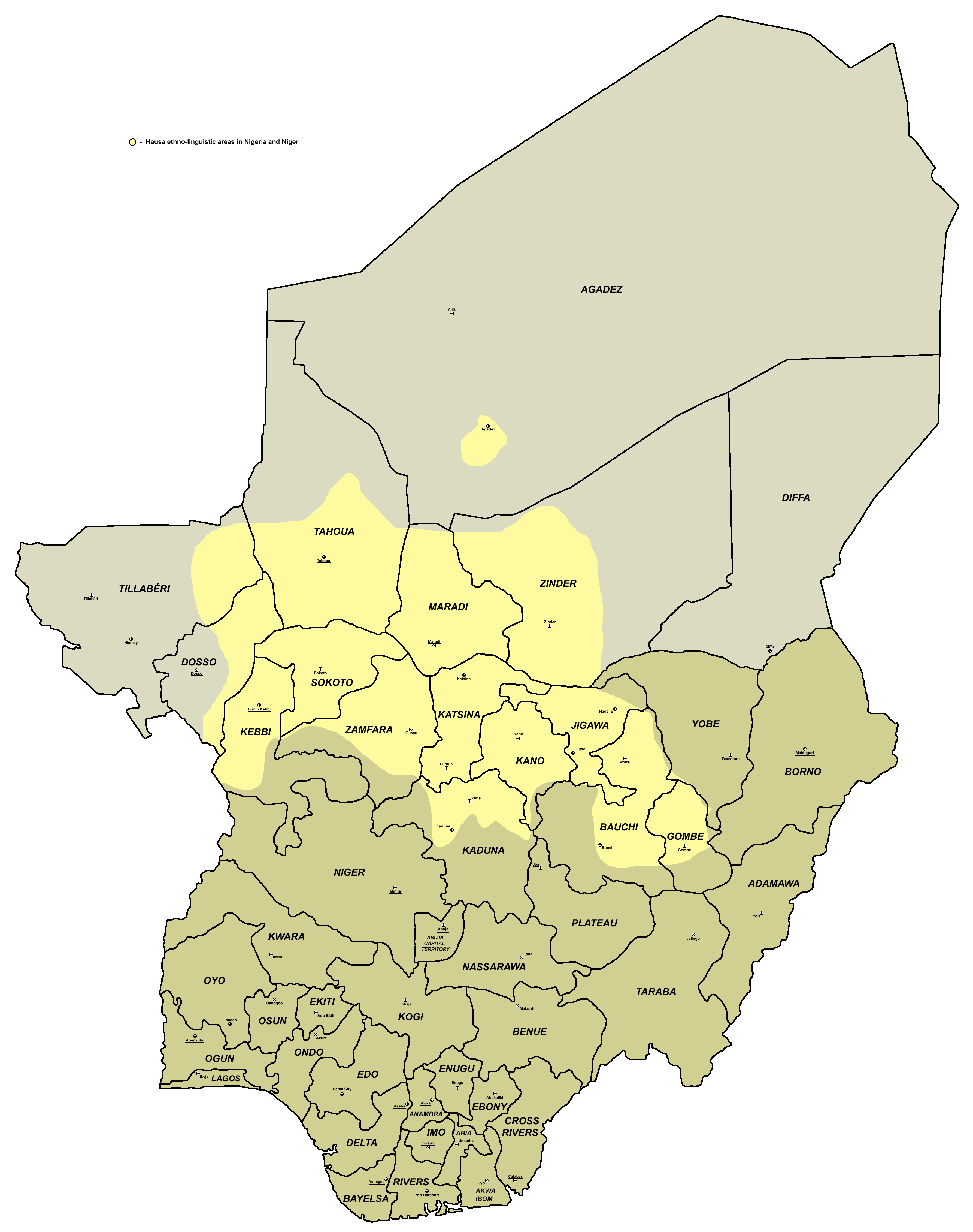
English: This map showcasing an actual settlement of hausa tribe and hausa speakers within Nigeria and Niger , |
||
| நாள் | |||
| மூலம் |
This file was derived from :
|
||
| ஆசிரியர் | Kwamikagami | ||
| ஒத்தக்கோப்பு |
|

அனுமதி
இந்த ஆக்கத்தின் காப்புரிமையாளரான Kwamikagami at ஆங்கிலம் விக்கிப்பீடியா எனும் நான் இதனைப் பின்வரும் உரிமத்தின் கீழ் வெளியிடுகின்றேன்:

|
GNU Free Documentation License விதிமுறைகளின் கீழ் இந்த ஆவணத்தை நகலெடுக்க, விநியோகிக்க மற்றும்/அல்லது மாற்றுவதற்கு அனுமதி வழங்கப்பட்டுள்ளது, Free Software Foundation;ஆல் வெளியிடப்பட்ட பதிப்பு 1.2 அல்லது அதற்குப் பிந்தைய பதிப்பு, மாற்றமில்லாத பிரிவுகள், முன் அட்டை உரைகள் மற்றும் பின் அட்டை உரைகள் இல்லாமல் வெளியிடப்பட்டது. GNU Free Documentation License என்ற தலைப்பில் உரிமத்தின் நகல் சேர்க்கப்பட்டுள்ளது. |
இந்த கோப்பு Creative Commons Attribution-Share Alike 3.0 Unported உரிமத்தின் கீழ் உள்ளது.
பண்புக்கூறுகள்:
- நீங்கள் சுதந்திரமாக:
- பகிர்ந்து கொள்ள – வேலையை நகலெடுக்க, விநியோகிக்க மற்றும் அனுப்ப
- மீண்டும் கலக்க – வேலைக்கு பழகிக்கொள்ள.
- கீழ்க்காணும் விதிகளுக்கு ஏற்ப,
- பண்புக்கூறுகள் – நீங்கள் பொருத்தமான உரிமையை வழங்க வேண்டும், உரிமத்திற்கான இணைப்பை வழங்க வேண்டும் மற்றும் மாற்றங்கள் செய்யப்பட்டிருந்தால் குறிப்பிட வேண்டும். நீங்கள் ஏற்புடைய எந்த முறையிலும் அவ்வாறு செய்யலாம், ஆனால் எந்த வகையிலும் உரிமதாரர் உங்களை அல்லது உங்கள் பயன்பாட்டிற்கு ஒப்புதல் அளிக்கும் படி பரிந்துரைக்க கூடாது.
- அதே மாதிரி பகிர் – நீங்கள் ரீமிக்ஸ் செய்தாலோ, உருமாற்றம் செய்தாலோ அல்லது பொருளை உருவாக்கினாலோ, உங்கள் பங்களிப்புகளை அல்லது இணக்கமான உரிமம் கீழ் அசலாக விநியோகிக்க வேண்டும்.
நீர் உமக்கு விருப்பமான உரிமத்தை தேர்ந்தெடுக்கலாம்.
References
- 1. Ethnic maps of Nigerian states from Nigeria's National Bureau of Statistics website: http://www.nigerianstat.gov.ng/maps.php archive copy at the Wayback Machine
- 2. Borders of Nigerian states (and locations of state capitals) are drawn according to the UN map of Nigeria: http://commons.wikimedia.org/wiki/File:Un-nigeria.png
- 3. Sizable cities in the part of Nigeria inhabited by Hausa people are selected in accordance with the info from World Gazetteer page for Nigeria: http://world-gazetteer.com/wg.php?x=&men=gadm&lng=en&des=wg&geo=-158&srt=npan&col=abcdefghinoq&msz=1500 archive copy at the Wayback Machine
- 4. Linguistic map of Niger from www.ethnologue.com: http://www.ethnologue.com/maps/ner_eth.jpg
- 5. Borders of provinces of Niger (and locations of provincial capitals) are drawn according to the UN map of Niger: http://commons.wikimedia.org/wiki/File:Un-niger.png
- 6. Sizable cities in Niger are selected in accordance with the info from World Gazetteer page for Niger: http://world-gazetteer.com/wg.php?x=&men=gcis&lng=en&des=wg&srt=npan&col=abcdefghinoq&msz=1500&geo=-156[dead link]
- 7. Aditional source about presence of Hausa speakers in Agadez: http://www.saudiaramcoworld.com/issue/200301/agadez-sultanate.of.the.sahara.htm archive copy at the Wayback Machine
Original upload log
The original description page was here. All following user names refer to en.wikipedia.
- 2012-04-06 21:47 Kwamikagami 2413×3077× (972777 bytes) Uploading a self-made file using [[Wikipedia:File_Upload_Wizard|File Upload Wizard]]
கோப்பின் வரலாறு
குறித்த நேரத்தில் இருந்த படிமத்தைப் பார்க்க அந்நேரத்தின் மீது சொடுக்கவும்.
| நாள்/நேரம் | நகம் அளவு சிறுபடம் | அளவுகள் | பயனர் | கருத்து | |
|---|---|---|---|---|---|
| தற்போதைய | 18:36, 28 அக்டோபர் 2014 | | 3,571 × 4,519 (447 KB) | wikimediacommons>WikiEditor2004 | aesthetically improved version + more accurate legend description per used sources |
கோப்பு பயன்பாடு
பின்வரும் பக்க இணைப்புகள் இப் படிமத்துக்கு இணைக்கபட்டுள்ளது(ளன):