படிமம்:IVC Map.png
Jump to navigation
Jump to search
இந்த முன்னோட்டத்தின் அளவு: 240 × 209 படப்புள்ளிகள் . மற்ற பிரிதிறன்: 459 × 400 படப்புள்ளிகள் .
மூலக்கோப்பு (459 × 400 படவணுக்கள், கோப்பின் அளவு: 110 KB, MIME வகை: image/png)
சுருக்கம்
| விளக்கம் |
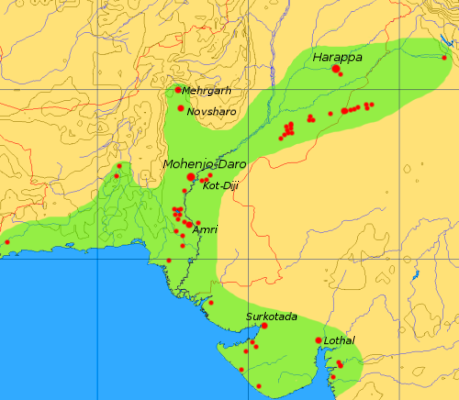
English: This map is a provisional outline of the Indus Civilization based on online sources. It is the best GFDL map we have so far, but it should be redrawn with greater accuracy and proper source attribution.
The main source of the present map is a scan of some unidentified publication, [1]. Better maps: |
| மூலம் | சொந்த முயற்சி |
| ஆசிரியர் | Dbachmann (பேச்சு · பங்களிப்புகள்) |
| ஒத்தக்கோப்பு | Image:CiviltàValleIndoMappa.png, de:Bild:Karte Harappa.png |
![[1]](http://content.answers.com/main/content/wp/en/thumb/d/dd/350px-Indus_Map.jpg)
அனுமதி

|
GNU Free Documentation License விதிமுறைகளின் கீழ் இந்த ஆவணத்தை நகலெடுக்க, விநியோகிக்க மற்றும்/அல்லது மாற்றுவதற்கு அனுமதி வழங்கப்பட்டுள்ளது, Free Software Foundation;ஆல் வெளியிடப்பட்ட பதிப்பு 1.2 அல்லது அதற்குப் பிந்தைய பதிப்பு, மாற்றமில்லாத பிரிவுகள், முன் அட்டை உரைகள் மற்றும் பின் அட்டை உரைகள் இல்லாமல் வெளியிடப்பட்டது. GNU Free Documentation License என்ற தலைப்பில் உரிமத்தின் நகல் சேர்க்கப்பட்டுள்ளது. |
| இந்த கோப்பு Creative Commons Attribution-Share Alike 3.0 Unported உரிமத்தின் கீழ் உள்ளது. | ||
| ||
| This licensing tag was added to this file as part of the GFDL licensing update. |
கோப்பின் வரலாறு
குறித்த நேரத்தில் இருந்த படிமத்தைப் பார்க்க அந்நேரத்தின் மீது சொடுக்கவும்.
| நாள்/நேரம் | நகம் அளவு சிறுபடம் | அளவுகள் | பயனர் | கருத்து | |
|---|---|---|---|---|---|
| தற்போதைய | 15:08, 6 செப்டெம்பர் 2005 | | 459 × 400 (110 KB) | wikimediacommons>Dbachmann | update |
கோப்பு பயன்பாடு
பின்வரும் 2 பக்கங்கள் இணைப்பு இப் படிமத்துக்கு இணைக்கபட்டுள்ளது(ளன):