படிமம்:Mongolia 1996 CIA map.jpg
மூலக்கோப்பு (2,000 × 1,649 படவணுக்கள், கோப்பின் அளவு: 1.33 MB, MIME வகை: image/jpeg)

|
This map image could be re-created using vector graphics as an SVG file. This has several advantages; see Commons:Media for cleanup for more information. If an SVG form of this image is available, please upload it and afterwards replace this template with
{{vector version available|new image name}}.It is recommended to name the SVG file “Mongolia 1996 CIA map.svg”—then the template Vector version available (or Vva) does not need the new image name parameter. |


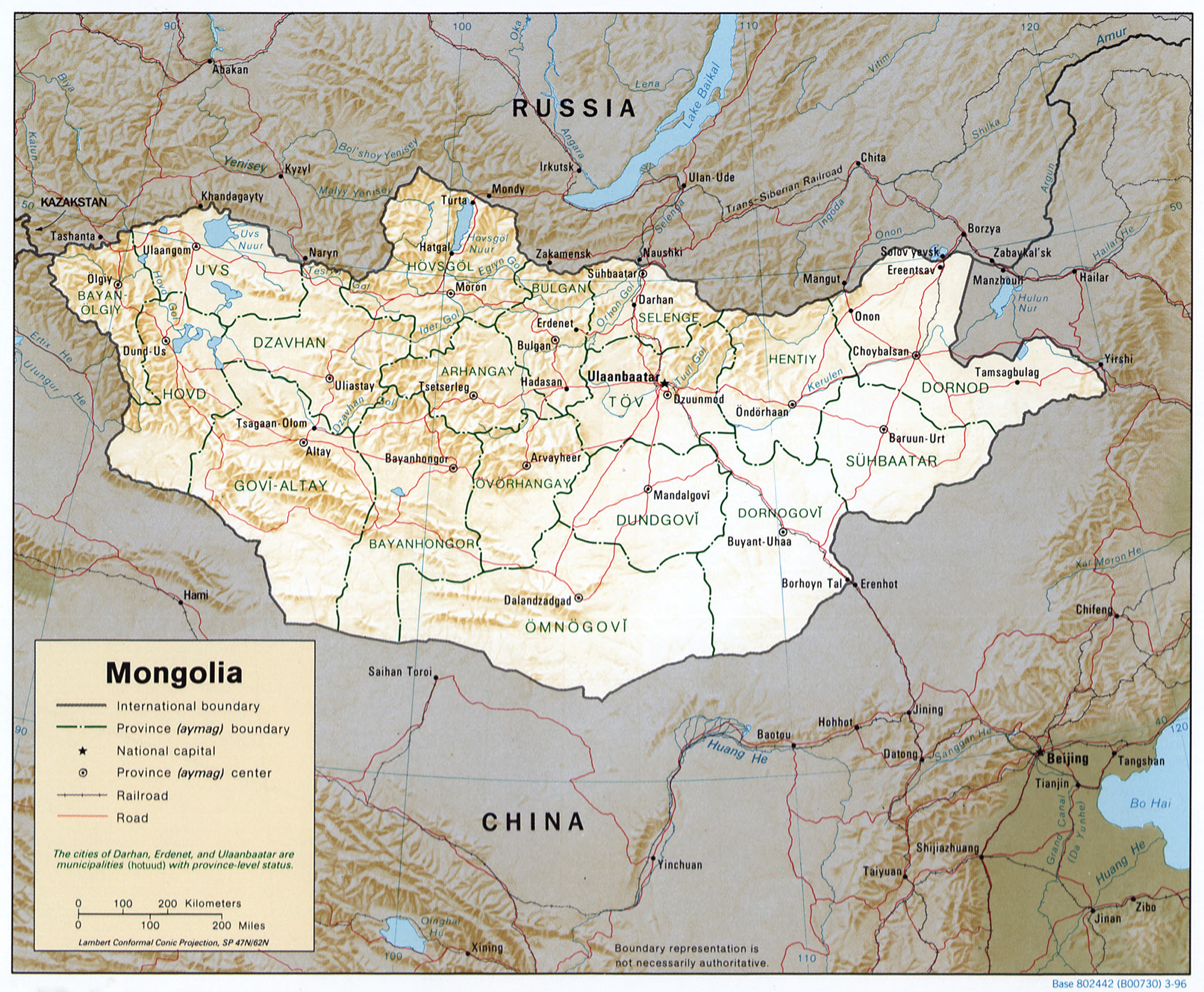
Mongolia.
United States. Central Intelligence Agency.
CREATED/PUBLISHED [Washington, D.C. : Central Intelligence Agency, 1996]
NOTES Relief shown by shading.
"Base 802442 (B00730) 3-96."
General map showing province boundaries, names, and capital cities.
Also issued without shaded relief.
Includes notes.
Scale [ca. 1:13,000,000] ; Lambert conformal conic proj. (E 870--E 1200/N 530--N 420).
SUBJECTS Mongolia--Maps. Mongolia--Administrative and political divisions--Maps. Mongolia.
MEDIUM 1 map : col. ; 17 x 21 cm.
CALL NUMBER G7895 1996 .U6
REPOSITORY Library of Congress Geography and Map Division Washington, D.C. 20540-4650 USA
DIGITAL ID g7895 ct001292 http://hdl.loc.gov/loc.gmd/g7895.ct001292
| This image is a work of a Central Intelligence Agency employee, taken or made as part of that person's official duties. As a Work of the United States Government, this image or media is in the public domain in the United States.
|

|
கோப்பின் வரலாறு
குறித்த நேரத்தில் இருந்த படிமத்தைப் பார்க்க அந்நேரத்தின் மீது சொடுக்கவும்.
| நாள்/நேரம் | நகம் அளவு சிறுபடம் | அளவுகள் | பயனர் | கருத்து | |
|---|---|---|---|---|---|
| தற்போதைய | 02:18, 27 அக்டோபர் 2005 | | 2,000 × 1,649 (1.33 MB) | wikimediacommons>Renamed user 8890c9ea641cb56d0315a459098630a3 | Mongolia. United States. Central Intelligence Agency. CREATED/PUBLISHED [Washington, D.C. : Central Intelligence Agency, 1996] NOTES Relief shown by shading. "Base 802442 (B00730) 3-96." General map showing province boundaries, names, and capital cit |
கோப்பு பயன்பாடு
பின்வரும் பக்க இணைப்புகள் இப் படிமத்துக்கு இணைக்கபட்டுள்ளது(ளன):